


Key points
Why It Matters
Many state and local health departments lack the tools for local, scalable disease modeling, which could provide critical insights for better, faster outbreak response.
Insight Net centers develop data-driven tools, models, and dashboards that bring together local health and environmental data to create actionable insights. Public health and healthcare leaders use these insights for timely, targeted, and efficient outbreak response and preparedness.
EpiENGAGE
State and local health departments across the country use epiENGAGE’s open-source disease modeling tools to inform outbreak response and preparedness in their communities.
- Led by: University of Texas, Austin
- Website: www.epiengage.org/
EpiENGAGE creates and implements open-source data tools for disease modelers across the country so they can collaborate, validate, and deliver critical insights during outbreaks. EpiENGAGE started with Hubverse, a platform for state-level modeling, and is now implementing MetroCast Hub to zoom in on city-level flu forecasting. Tools like these, which work at multiple geographic levels, are important to identify larger trends while also picking up on differences across communities. This precision enables tailored responses and gives state and local public health partners access to real-time modeling for better outbreak preparedness and improved response decision-making.

MADMC
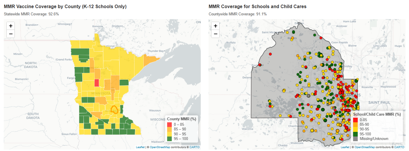
MADMC's Midwest EpiView: MMR Coverage & Measles supports local public health officials, schools, and health systems in effectively preparing for and responding to measles outbreaks in Minnesota.
- Midwest Analytics and Disease Modeling Center (MADMC)
- Led by: University of Minnesota
- Website: www.sph.umn.edu/research/centers/midwest-analytics-and-disease-modeling/
MADMC worked with the Minnesota Department of Health to create Midwest EpiView: MMR Coverage & Measles, a public interactive dashboard that displays measles, mumps, and rubella (MMR) vaccine coverage data for schools and childcare centers in Minnesota as well as historical measles case data. The dashboard can help public health officials prepare for measles outbreaks on a hyper-local level, revealing where additional support and resources might need to be directed during an outbreak. Schools and health systems can use Midwest EpiView to understand vaccine coverage among their populations and prepare targeted messaging, staffing, or logistical support as necessary.
DMA-PRIME
South Carolina is identifying and delivering resources to medically underserved areas using DMA-PRIME modeling tools.
- Disease Modeling and Analytics to inform outbreak Prevention, Response, Intervention, Mitigation, and Elimination (DMA-PRIME)
- Led by: Clemson University
- Website: www.clemson.edu/cbshs/phmr
DMA-PRIME creates tools that integrate respiratory disease data with information about medical resources and community needs in South Carolina. These tools help inform the placement of mobile health clinics across the state to medically underserved areas. DMA-PRIME's work with state health partners creates a foundation for more efficient resource allocation and improves access to lifesaving care, ultimately supporting readiness and response to infectious disease threats. To make these data-driven insights more accessible, DMA-PRIME integrates them into a straightforward software package that is easy to use for non-expert practitioners, while still providing specific, detailed information for resource placement.

MICOM
Health departments across Michigan are efficiently preparing for and responding to vaccine-preventable diseases using MICOM’s disease models and visualization tools.
- Michigan Public Health Integrative Center for Outbreak Analytics and Modeling (MICOM)
- Led by: University of Michigan
- Website: www.micom-insight.net/
MICOM’s interactive data visualization dashboard, MI-Lighthouse, supports disease modeling and maps vaccination coverage at the hyper-local level. The tool helps users identify areas that are vulnerable to vaccine-preventable diseases. MICOM shares estimates with local health departments so that they can prepare for and control disease cases before they become large outbreaks. Health departments in nearly every county in Michigan use the tool to inform planning, community outreach, and communication strategies. In 2026, MICOM integrated school-level immunization coverage and waiver data into the dashboard, helping local decision-makers visualize where immunity gaps exist, where cases are rising, and where interventions and resources are likely to have the greatest impact.

Resilient Shield
Health departments in Southern California are taking action to address pollution from the Tijuana River using Resilient Shield’s health and environmental modeling tools.
- Led by: University of California, San Diego
- Website: www.resilientshield.ucsd.edu/
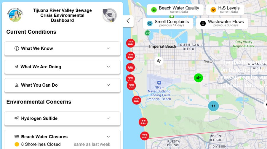
Resilient Shield's public health dashboard combines environmental data sources to provide a full picture of the Tijuana River pollution and sewage crisis. It brings together information about beach closures, water quality, sewage spills, air pollution, and related health problems like stomach and breathing problems—all packaged in an accessible, easy-to-understand, interactive format for the public. San Diego County uses the dashboard to collaborate with state, federal and international partners to stop the flow of raw sewage and mitigate air and water pollution. The project also helps community members plan when and where it is safe to recreate.
This page was last updated on this date. Updates may include minor edits, image changes, or other modifications to page content.
The information on this page was last reviewed by subject matter experts to ensure accuracy.