


Key points
Map
Map details
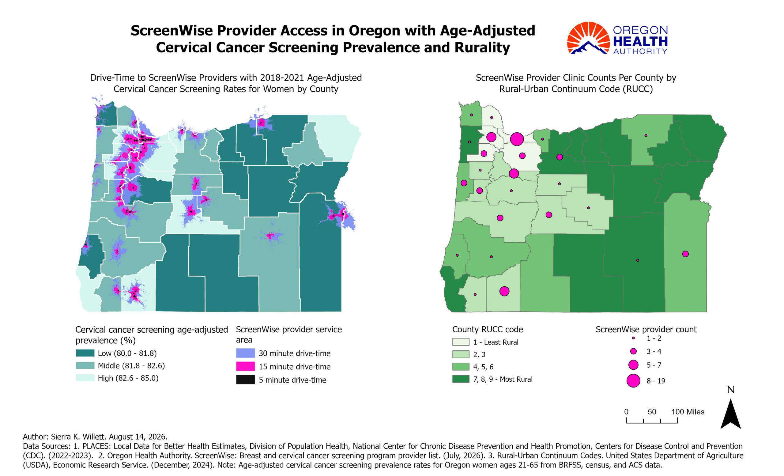
This map shows county-level age-adjusted rates for cervical cancer screening in Oregon from 2018-2022 amongst women ages 21-65, by county for Oregon's 36 counties. ScreenWise provider access is concentrated geographically near population centers in the western region of Oregon, which is less rural. The more rural counties in eastern and southern Oregon have fewer providers and longer travel times. Fewer rural counties are within 5, 15, and 30 minutes service areas of a ScreenWise provider.
ArcGIS Pro
- BRFSS/PLACES
- Health care locations
- U.S. Census
- U.S. Department of Agriculture
Age-adjusted cervical cancer screening prevalence rates were classified using tertiles for display. A drive-time analysis was conducted to delineate 30, 15, and 5 minute service areas around Screenwise provider locations. Provider locations in Oregon were geocoded and aggregated to the county level, and county-level counts were visualized using graduated symbols to compare the number of available sites. County rurality was depicted using the USDA Rural–Urban Continuum Codes.
This map will be used to inform the health department on the geographic patterns of cervical cancer screening, proximity to ScreenWise clinics, and rurality. It can be used by our ScreenWise division and developed into an interactive map that can be accessed online by Oregonians to find their nearest ScreenWise provider location.
Sierra Willett, Research Analyst 3
Oregon Health Authority
971-288-8732
sierra.k.willett@oha.oregon.gov
Sierra Willett, Oregon Health Authority. Accessed from the Centers for Disease Control and Prevention’s Chronic Disease GIS Map Gallery. https://www.cdc.gov/heart-disease-and-stroke-data/data-vis/or-screenwise.html
This page was last updated on this date. Updates may include minor edits, image changes, or other modifications to page content.
The information on this page was last reviewed by subject matter experts to ensure accuracy.