


Key points
Map
Map details
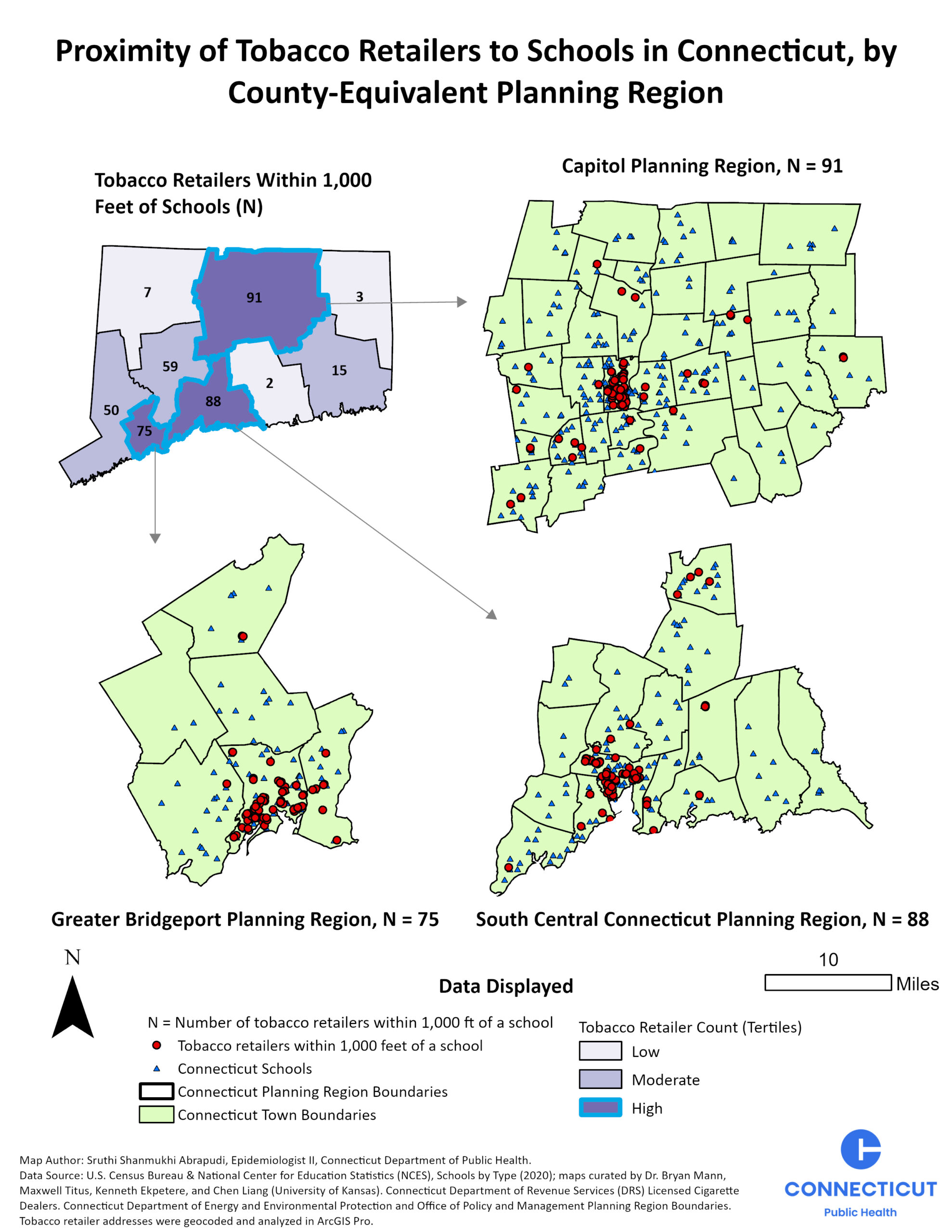
This map displays three Connecticut county-equivalent planning regions (CEPRs)—Capitol Planning Region, Greater Bridgeport Planning Region, and South Central Connecticut Planning Region—with the highest number of tobacco retailers within 1,000 feet (less than a quarter mile) of schools, layered on 2020 National Center for Education Statistics (NCES) school data. The Capitol Planning Region has the highest number, with 91 tobacco retailers within 1,000 feet of schools. South Central Connecticut has 88 retailers, and Greater Bridgeport has 75 retailers within 1,000 feet of schools.
The map shows that tobacco retailers within 1,000 feet of schools are concentrated in and around Connecticut's larger urban areas, particularly New Haven, Hartford, and Bridgeport. These areas have visible clusters of tobacco retailers in proximity to schools, highlighting geographic patterns in the availability of tobacco retailers near educational settings.
MS Excel, ArcGIS Pro Desktop
U.S. Census Bureau & National Center for Education Statistics (NCES); Schools by Type (2020); Connecticut Department of Revenue Services (DRS) Licensed Cigarette Dealers.
Connecticut licensed tobacco retailer locations were geocoded using ArcGIS Pro. Location data for Connecticut schools were added as a layer to the map, and a 1,000-foot buffer was created around school locations using the Pairwise Buffer tool.
‘Select By Location’ was used to identify tobacco retailers intersecting the 1,000-foot school buffer. Tobacco retailers were summarized by Connecticut planning region (CEPR). The number of tobacco retailers within 1,000 feet of a school was categorized into tertiles across CEPRs, with regions classified as low, moderate, or high based on the number of retailers. The highest tertile was highlighted in the map to identify CEPRs with the greatest number of tobacco retailers within 1,000 feet of a school.
The three regions with the highest number of tobacco retailers within 1,000 feet of a school were selected for detailed mapping. The selected regions were clipped and displayed as individual map frames.
This map can support Connecticut tobacco control planning by providing a geographic view of tobacco retailers located within 1,000 feet of schools across county-equivalent planning regions (CEPRs). Tobacco control programs, local health departments, and community partners can use the map to identify areas with higher concentrations of retailers near schools, prioritize community-level prevention efforts, inform tobacco control strategies, and support collaboration with local partners to promote healthier, tobacco-free communities.
Sruthi Shanmukhi Abrapudi, Epidemiologist II
Connecticut Department of Public Health
860-509-7577
Sruthi.Abrapudi@ct.gov
Sruthi Shanmukhi Abrapudi, Conntecticut Department of Public Health. Accessed from the Centers for Disease Control and Prevention’s Chronic Disease GIS Map Gallery. https://www.cdc.gov/heart-disease-and-stroke-data/data-vis/ct-proximity-of-tobacco-retailers-to-schools.html
This page was last updated on this date. Updates may include minor edits, image changes, or other modifications to page content.
The information on this page was last reviewed by subject matter experts to ensure accuracy.