Mining Project: Geologic Parameters for Identifying Areas of Increased Methane and Mining-induced Seismicity at Deep Coal Mines
| Principal Investigators |
|
|---|---|
| Start Date | 10/1/2022 |
| End Date | 9/30/2023 |
| Objective |
This pilot project was a one-year effort to evaluate the geological variables linked to high methane concentrations and increased mining-induced seismicity in underground coal mines. The project determined what lithological and mining conditions led to higher methane production at a case study site in 2020 and created a map to highlight where higher methane concentrations could exist within the future mining area. This project assessed geological and mining conditions that led to anomalous seismic events in 2016 at the case study site to help develop methodologies for generating seismic potential maps for underground coal mines. Both high methane and seismic activity may create possible hazardous mining conditions that could be avoided if early warning methods could alert miners prior to mining certain areas. |
| Topic Area |
Research Summary
Approach
The research combined field studies, numerical modeling, and data analysis. Research was conducted in various areas of the Buchanan mine, Virginia, where excess methane production and destructive seismic activities have been experienced. To understand conditions leading to high methane concentrations, areas with excess methane production were compared to areas with standard methane production to determine their geological differences.
Seismicity was modeled in panels that had relatively low and high levels of seismic activities to calibrate the model response to seismic hazard against historic seismic data. The models were compared geologically to determine the lithology differences that led to a panel being high or low in relation to seismic risk.
Milestones and Accomplishments
| Description | Audience | Year |
|---|---|---|
| Constructed a 3DEC model and evaluated the seismic potential results of new panel designs. | Academia and mine managers | 2023 |
| Produced a model with calibrated parameters capable of distinguishing areas of low potential from high potential in relation to seismic hazard. | Academia and mine managers | 2023 |
Impacts and Outcomes
This pilot project examined the geological conditions of the high methane area of the Buchanan mine and compared these conditions to other areas that had not experienced such high methane production. From this data, a map can be produced to indicate other possible areas of high methane production in future mining areas. From historic seismic data, methodologies and numerical models were generated to replicate the seismic potentials in previous districts. The methodologies and calibrated models can be used to develop seismic forecasting map for different mine layouts. The findings for assessing high-methane-concentration and high-seismic-activity conditions may potentially be applied to mines with similar geology such as longwall mines in Alabama and Utah, but further research is required for generalizing the developed methodologies to various geology and mining conditions.
Outputs
Outputs were in the form of peer-reviewed journal articles, conference proceedings, and technical presentations related to creating the framework for developing a seismic forecasting map for the underground coal mine.
Supporting Visual
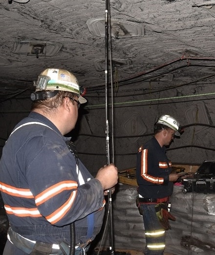
NIOSH employees operating a high-definition borescope to record the lithology in the mine roof prior to installing a roof extensometer.
- Degasification System Selection for U.S. Longwall Mines Using an Expert Classification System
- Development and Application of Reservoir Models and Artificial Neural Networks for Optimizing Ventilation Air Requirements in Development Mining of Coal Seams
- Drainage of Methane From the Overlying Pocahontas No. 4 Coalbed From Workings in the Pocahontas No. 3 Coalbed
- Guidelines for the Control and Monitoring of Methane Gas on Continuous Mining Operations
- Ignition of Methane-Air Mixtures by Laser Heated Small Particles
- Modeling and Prediction of Ventilation Methane Emissions of U.S. Longwall Mines Using Supervised Artificial Neural Networks
- Remote Methane Sensors
- Reservoir Engineering Considerations for Coal Seam Degasification and Methane Control in Underground Mines
- Reservoir Rock Properties of Coal Measure Strata of the Lower Monongahela Group, Greene County (Southwestern Pennsylvania), from Methane Control and Production Perspectives
- Stochastic Modeling of Gob Gas Venthole Production Performances in Active and Completed Longwall Panels of Coal Mines