Geographic Distribution of Acute Chemical Incidents — Hazardous Substances Emergency Events Surveillance, Nine States, 1999–2008
Corresponding author: Randall Young, Division of Toxicology and Human Health Sciences, Agency for Toxic Substances and Disease Registry, CDC. Telephone: 770-488-3857; E-mail: rby5@cdc.gov.
Abstract
Problem/Condition: Hazardous chemicals are transported and used widely in the United States, and acute chemical releases (lasting <72 hours) are not uncommon. Characterizing acute incidents within geographic areas can help researchers identify spatial patterns and differences and enable public and environmental health and safety practitioners, members of local emergency planning committees, preparedness coordinators, industry managers, emergency responders, and others to prepare for and respond to chemical incidents.
Reporting Period: 1999–2008.
Description of System: The Hazardous Substances Emergency Events Surveillance (HSEES) system was operated by the Agency for Toxic Substances and Disease Registry (ATSDR) during January 1991-September 2009 to collect data on hazardous chemical releases that would enable researchers to describe the public health consequences of these acute releases and to develop activities aimed at reducing the ensuing harm to the public. This report summarizes data for the geographic distribution of reported acute incidents by states, counties, and Metropolitan Statistical Areas (MSAs) from the nine states (Colorado, Iowa, Minnesota, New York, North Carolina, Oregon, Texas, Washington, and Wisconsin) that participated in HSEES during its last 10 full years of data collection (1999–2008).
Results: A total of 57,975 acute incidents occurred during 1999–2008; five MSAs accounted for 40.1% of all incidents. Texas reported 41% of all incidents reported by the nine states during the 10-year study period, and Colorado reported the fewest incidents (3.4%).
Interpretation: Storage, use, and transport of hazardous substances often are associated with unanticipated releases. In general, releases occurred more frequently in areas that use or store more hazardous chemicals and in urbanized areas compared with rural areas. In rural areas, most incidents were related to the transport of hazardous chemicals. The primary economic activities in an area had a strong influence on the frequency and type of chemicals released in the area.
Public Health Implications: Exposure to hazardous chemicals can have immediate and serious health consequences. Harmful releases can occur wherever hazardous chemicals are used, stored, or transported. The time and location of releases is unpredictable. Taken together, these elements underscore the need for preparedness. A culture of safety, prevention, and preparedness can minimize the consequences of future incidents.
Introduction
The chemical industry is a major component of the U.S. economy, accounting for >600,000 jobs and more than $49 billion in payroll in 2011 (1). The chemical industry manufactures all sorts of substances for consumer products, agriculture, and every major sector of the U.S. economy. Chemical substances usually are controlled during production, distribution, and use, thereby limiting human and environmental exposures. Although many of the substances produced and used will have no harmful public health consequences, other chemicals pose a danger to health. Hazardous chemicals are transported and used widely in the United States, and chemical releases are not uncommon. The U.S. Department of Transportation estimates that nearly 1 million shipments of hazardous materials occur daily in the United States (2). When hazardous chemicals are released, serious consequences (e.g., environmental damage and human exposure) can ensue that result in morbidity or mortality. A total of 1,177 injuries were associated with acute chemical incidents in 2011, including 62 deaths (3).
The Hazardous Substances Emergency Events Surveillance (HSEES) database provides information on the characteristics and spatial and temporal dimensions of hazardous chemical releases within the states that participated in the surveillance system (4). This report provides an overview of the geographic distribution of hazardous chemical releases occurring in selected states during 1999–2008 and is a part of a comprehensive surveillance summary (5). Public and environmental health and safety practitioners, worker representatives, emergency planners, preparedness coordinators, industry managers, emergency responders, and others who prepare for or respond to chemical incidents can use the findings in this report to prepare for and prevent chemical incidents and injuries.
Methods
This report is based on data reported to HSEES by health departments in nine states (Colorado, Iowa, Minnesota, New York, North Carolina, Oregon, Texas, Washington, and Wisconsin) that participated in HSEES during its last 10 complete calendar years of data collection (1999–2008). Data from 2009 were not included because several states ended data collection mid-year. A detailed description of the HSEES data used in this analysis is found elsewhere (6). Case definitions, exclusion criteria, and 2006 changes in reporting guidelines used for this analysis are described (Box).
HSEES defined an injured person as a person who experienced at least one documented acute adverse health effect (i.e., one occurring in <24 hours) or who died as a consequence of the event; injured persons must have had at least one injury type or symptom, and up to seven could be listed (7).
This report describes the geographic distribution of the incidents by aggregating them to three levels: state, county, and Metropolitan Statistical Area (MSA).* Summarizing the data over geographic areas reveals spatial patterns across the study area. Boundaries and population data from the 2000 U.S. Census were used (8). The maps were generated by using ArcGIS software (ESRI, ArcMap v10). In 2000, the U.S. Census Bureau delineated 111 MSAs in the nine study states. At the MSA level, a density of incidents was derived by dividing the number of incidents recorded within each MSA by the MSA's area (in square miles). MSAs in the top 20% of density of incidents then were mapped.
Most of the analyses were made on the basis of simple counts of incidents within states, counties, or MSAs. The first step was to ascertain the overall number of incidents within the various geographic areas. At the state level, the frequency with which various substances were released was considered. HSEES recorded all substances that were released at all incidents. For each state, the database was searched for the five chemicals which were released most frequently. The industry associated with each incident was coded by using the U.S. Census Bureau's 2002 North American Industry Classification System (NAICS). For each state, the database was searched to ascertain which five NAICS industry categories appeared most frequently. Data from the 2002 U.S. Economic Census were used to characterize the economic activities in each state (9).
At the county level, the number of HSEES incidents in relation to each county's urban or rural character was considered by using the urban-rural continuum codes established by the U.S. Department of Agriculture for 2003 (10) (Table 1). For each county, the ratio of transportation-related incidents to incidents at fixed facilities was calculated. The transportation versus fixed ratios to the counties' urban-rural codes were compared by calculating the average ratio for each urban/rural category.
At the county level, the number of HSEES incidents was compared with the quantity of chemicals stored at sites that reported to the Environmental Protection Agency's Toxics Release Inventory (TRI) (11). The TRI database records the quantity of chemicals stored at each TRI facility as a range of pounds. The midpoint of each range was used to approximate the number of pounds at each facility. The codes and ranges defined by TRI, along with the midpoint values (in pounds) used for each, are summarized (Table 2). The approximated weights for all TRI sites within each county were summed. Finally, the statistical correlation (Pearson's r) between the number of HSEES incidents and the approximated total weight of chemicals stored at TRI sites in each county was calculated.
Results
A total of 57,975 incidents were recorded by the nine states during the 10-year study period (Figure 1). With one exception (Oregon, December 1999), at least one incident was recorded for each state during every month. The greatest number of incidents in a single state during a single month was 304 recorded for Texas in October 2002. Texas reported by far the greatest number of incidents, accounting for 41% of all incidents reported by the nine states. Colorado had the fewest incidents, with 1,943 during the 10-year study period (3.4% of all incidents in the study).
The number of incidents recorded for each state, as well as the proportion of fixed versus transport-related incidents, varied greatly (Figure 2). In six states (Iowa, Minnesota, New York, Oregon, Texas, and Washington), a greater proportion of incidents occurred at fixed facilities; in Texas, 85% of incidents occurred at fixed facilities. In three states (Colorado, North Carolina, and Wisconsin), the majority of incidents were transportation-related. At the county level, a correlation was identified between a county's urban-rural classification and the proportion of incidents that occurred in transit. On average, counties classified as rural had five times as many transit-related incidents as fixed-facility incidents.
The number of incidents in a state was correlated with the state's population, with Texas and New York having both the most chemical incidents and the largest populations. Of the nine states that participated in HSEES during the study period, the three least populous states (Colorado, Iowa, and Oregon) had the fewest chemical incidents.
Chemical incidents were reported in nearly all parts of each state. Among the 813 counties within the nine states, 43 counties recorded no incidents, and the remaining 770 counties had at least one incident. However, there was great variation among counties in the number of incidents. Combined, the 43 counties that reported no incidents and the 53 counties that reported only one incident represent 12% of all counties in the study states. In contrast, Harris County, Texas (which includes the city of Houston), recorded the greatest number of incidents in a single county: 7,051 incidents during the 10-year study period. The county-level descriptive statistics for the number of HSEES incidents reported in the nine states during the study period are listed (Table 3).
Of the nine states studied, Texas had the greatest variation in the number of incidents reported within its counties (standard deviation [SD]: 517). When the study counties are ranked by number of incidents reported, the top three counties (Brazoria, Harris, and Jefferson) were all in Texas. However, in 32 Texas counties, no incidents were reported during the entire 10-year period. Those 32 counties are mostly rural, comprising 13% of the state's area but containing <1% of its population. Iowa counties showed the least variation in the number of chemical incidents (SD: 42). Every county in Iowa had at least three incidents during the study period, and in one county (Polk), the greatest number of incidents recorded was 299.
The trend of more incidents occurring in more populous states also was reflected at the county level. The 20 most populous counties studied (3% of study counties) accounted for one third of all incidents reported, whereas the 406 counties comprising the lower 50% of population accounted for only 10% of incidents reported. In essence, chemical incidents occurred much more frequently in urban areas. The 10 MSAs within the study states that recorded the most incidents are listed (Table 4). Five MSAs accounted for 40% of all incidents. The MSAs in the top 20% are mapped in terms of density of incidents (incidents per square mile) within the study area (Figure 3).
A state's major economic activities generally were reflected by the number and type of incidents reported by that state. For example, Texas ranks first in the nation in terms of petroleum and chemical products manufacturing (3). The scale and intensity of those activities in Texas led to 11,381 releases associated with chemical and petroleum manufacturing processes. Texas accounted for 84% of all incidents that were related to chemical and petroleum manufacturing.
In Iowa, a leading agricultural state, one third of HSEES incidents were associated with agriculture or farm supplies. Iowa alone accounted for 46% of the incidents that were associated with crop production. A disproportionate number of the incidents in Iowa involved ammonia, likely attributable to the widespread use of ammonia as a fertilizer. Iowa reported 1,025 incidents involving ammonia, compared with 640 in Texas. For each state, the proportion of spills by industry sector and the proportion of the most often released chemicals are shown (Table 5).
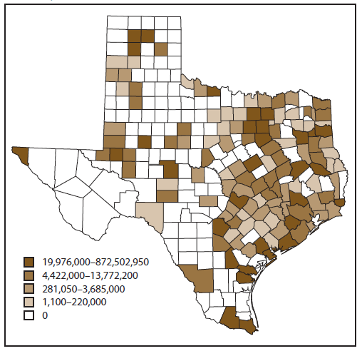
The number of incidents recorded in HSEES was compared by county to the number of pounds of chemicals documented by TRI for the state of Texas (Figures 4 and 5). Similar patterns were noted, consistent with the finding of a strong correlation (Pearson's r = +0.7) between the number of incidents in a county and the amount of chemicals used or stored at TRI facilities in the county.
Discussion
The HSEES data characterize the general scale and dimensions of an important public health problem. This analysis of 57,975 incidents that occurred in nine states during a 10-year period indicates that the storage, use, and transport of hazardous substances often is associated with unanticipated releases. Rather than describing individual incidents, this report describes the geographic distribution of the incidents by aggregating them to the state, county, and MSA levels. Four main findings were noted. First, areas that use or store more hazardous chemicals had more releases. Second, releases occurred more frequently in urbanized areas compared with rural areas. Third, in rural areas, most incidents were related to the transport of hazardous chemicals. Finally, the primary economic activities in an area had a strong influence on the frequency and type of chemicals released in the area.
Human exposures to toxic chemicals were recorded for many of the incidents. The database records 15,506 exposed persons during the 10-year period. Because releases generally occur more frequently in urbanized areas, there may be a greater likelihood that a given release could affect more people. However, urbanized areas generally have emergency response units and medical facilities that can treat persons with symptoms of chemical exposure. Releases are rare in rural and more isolated areas, but access to effective treatment also is limited in those areas.
Limitations
The findings in this report are subject to at least four limitations. First, despite the attempts to make the case definition the same among states, results are not comparable between states because reporting to HSEES was voluntary and data sources varied by state. Second, the results from these nine states might not be representative of the entire United States. Third, inconsistencies within and across states likely exist because reporting capacity (e.g., staffing) or local requirements varied. Specifically, certain states and localities had more stringent reporting regulations than the federal regulations or had more resources to conduct surveillance, possibly resulting in more reported incidents. These factors might have influenced the quality and number of reports or level of detail provided about the incidents. Finally, changes in reporting guidelines in 2006 (e.g., the reporting requirement changed based on the amount of the release to >10 pounds or >1 gallon or any release amount for substances on the HSEES mandatory list) could have led to increased reporting of some types of incidents and decreased reporting of others. This also could have affected the reports of industries that had releases.
Conclusion
Harmful releases can occur wherever hazardous chemicals are used, stored, or transported, underscoring the need for preparedness. Surveillance programs cannot be used to predict when and where the next incidents will occur. But understanding the overall pattern is helpful because releases will likely continue: both accidental and intentional incidents will occur in populous areas, and some of the releases will have serious health consequences, including death. The value of surveillance activities such as HSEES is that they enable researchers to understand overall patterns that should inform prevention and preparedness decisions. A culture of safety, prevention, and preparedness can minimize the consequences of future incidents.
Acknowledgments
Assistance in the preparation of this report was provided by L. Lászlo Pallos, PhD, and Jennifer Wu, MS.
References
- US Census Bureau. 2011 annual survey of manufactures. Washington, DC: US Census Bureau; 2011. Available at http://factfinder.census.gov/faces/tableservices/jsf/pages/productview.xhtml?pid=ASM_2011_31GS201&prodType=table.
- US Department of Transportation. For the public. Washington, DC: Pipeline and Hazardous Materials Safety Administration 2015. Available at http://www.phmsa.dot.gov/public.
- Agency for Toxic Substances and Disease Registry. National Toxic Substance Incidents Program (NTSIP) annual report, 2011. Atlanta, GA: US Department of Health and Human Services, Agency for Toxic Substances and Disease Registry; 2011. Available at http://www.atsdr.cdc.gov/ntsip/docs/ATSDR_Annual%20Report_121013_508%20compliant.pdf.
- Agency for Toxic Substances and Disease Registry. Hazardous Substances Emergency Events Surveillance. Atlanta, GA: US Department of Health and Human Services, Agency for Toxic Substances and Disease Registry, CDC; 2015. Available at http://www.atsdr.cdc.gov/HS/HSEES.
- CDC. Hazardous Substances Emergency Events Surveillance, nine states, 1999-2008. MMWR Surveill Summ 2015;64(No. SS-2).
- Orr MF, Sloop S, Wu J. Acute chemical incidents surveillance-Hazardous Substances Emergency Events Surveillance, nine states, 1999-2008. In: CDC. Hazardous Substances Emergency Events Surveillance, nine states, 1999-2008. MMWR Surveill Summ 2015;64(No. SS-2).
- Agency for Toxic Substances and Disease Registry. Hazardous Substances Emergency Events Surveillance: biennial report 2007-2008. Atlanta, GA: US Department of Health and Human Services, Agency for Toxic Substances and Disease Registry, CDC. Available at http://www.atsdr.cdc.gov/HS/HSEES/annual2008.html.
- US Census Bureau. 2000 TIGER/line files. Washington, DC: US Department of Commerce, US Census Bureau; 2001. Available at http://www.census.gov/geo/maps-data/data/tiger-line.html.
- US Census Bureau. 2002 economic census. Washington, DC: US Department of Commerce, US Census Bureau; 2003. Available at http://www.census.gov/econ/census/data/historical_data.html.
- Economic Research Service. Rural-urban continuum codes. Washington, DC: US Department of Agriculture, Economic Research Service; 2013. Available at http://www.ers.usda.gov/data-products/rural-urban-continuum-codes.aspx.
- Office of Environmental Information. Toxics Release Inventory (TRI) program. Washington, DC: US Environmental Protection Agency, Office of Environmental Information; 2015. Available at http://www2.epa.gov/toxics-release-inventory-tri-program.
- Office of Management and Budget. OMB Bulletin No. 13-01: revised delineations of metropolitan statistical areas, micropolitan statistical areas, and combined statistical areas, and guidance on uses of the delineations of these areas. Washington, DC: Office of Management and Budget; 2013. Available at http://www.whitehouse.gov/sites/default/files/omb/bulletins/2013/b-13-01.pdf.
* MSAs are U.S. Census-defined conglomerations of counties around a metropolitan core area (12).
|
TABLE 1. U.S. Department of Agriculture urban-rural continuum codes, 2003 |
|
|---|---|
|
Code |
Description |
|
1 |
County in metro area with ≥1 million population |
|
2 |
County in metro area of 250,000–1 million population |
|
3 |
County in metro area of <250,000 population |
|
4 |
Nonmetro county with urban population of ≥20,000, adjacent to a metro area |
|
5 |
Nonmetro county with urban population of ≥20,000, not adjacent to a metro area |
|
6 |
Nonmetro county with urban population of 2,500–19,999, adjacent to a metro area |
|
7 |
Nonmetro county with urban population of 2,500–19,999, not adjacent to a metro area |
|
8 |
Nonmetro county completely rural or <2,500 urban population, adjacent to metro area |
|
9 |
Nonmetro county completely rural or <2,500 urban population, not adjacent to metro area |
|
Source: US Department of Agriculture, Economic Research Service. Rural-urban continuum codes. Washington, DC: US Department of Agriculture; 2013. Available at http://www.ers.usda.gov/data-products/rural-urban-continuum-codes.aspx. |
|
FIGURE 1. Number* of acute chemical incidents, by state — Hazardous Substances Emergency Events Surveillance system, nine states,† 1999–2008§
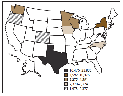
* N = 57,975.
† Iowa, Minnesota, New York, North Carolina, Oregon, Texas, Washington, and Wisconsin.
§ Cutpoints for categories determined by using Jenks Natural Breaks Optimization in ArcGIS.
Alternate text: The figure is a map of the United States that shows the distribution of the 57,975 acute chemical incidents that were reported in the nine states (Iowa, Minnesota, New York, North Carolina, Oregon, Texas, Washington, and Wisconsin) that participated in the Hazardous Substances Emergency Events Surveillance system during 1999–2008.
FIGURE 2. Number* of acute chemical incidents, by type — Hazardous Substances Emergency Events Surveillance system, nine states, 1999–2008
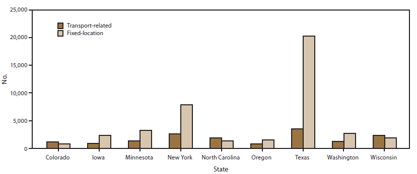
* N = 57,960. Total excludes 15 incidents for which type was not reported.
Alternate text: The figure is a bar chart that shows the distribution of acute chemical incidents by type (fixed-location versus transport-related) for the 57,960 incidents for which type was reported in the nine states (Iowa, Minnesota, New York, North Carolina, Oregon, Texas, Washington, and Wisconsin) that participated in the Hazardous Substances Emergency Events Surveillance system during 1999–2008. The number of incidents recorded for each state, as well as the proportion of fixed versus transport-related incidents, varied greatly. In six states (Iowa, Minnesota, New York, Oregon, Texas, and Washington), a greater proportion of incidents occurred at fixed facilities; in Texas, 85% of incidents occurred at fixed facilities. In three states (Colorado, North Carolina, and Wisconsin), the majority of incidents were transportation-related.
FIGURE 3. Metropolitan statistical areas in the top quintile of acute chemical incidents per 100 square miles — Hazardous Substances Emergency Events Surveillance system, nine states,* 1999–2008
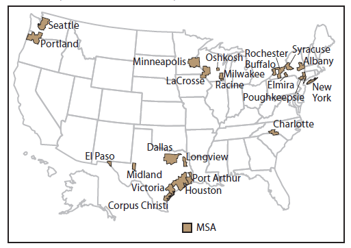
Abbreviation: MSA = metropolitan statistical area.
* Colorado, Iowa, Minnesota, New York, North Carolina, Oregon, Texas, Washington, and Wisconsin.
Alternate text: The figure is a map of the United States that shows the metropolitan statistical areas in the top quintile of acute chemical incidents per 100 square miles as reported in the nine states (Iowa, Minnesota, New York, North Carolina, Oregon, Texas, Washington, and Wisconsin) that participated in the Hazardous Substances Emergency Events Surveillance system during 1999–2008.
FIGURE 4. Number of acute chemical incidents, by quintile and county — Texas, Hazardous Substances Emergency Events Surveillance system, 1999–2008
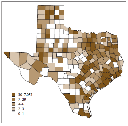
Alternate text: The figure is a map of the state of Texas that shows the distribution by quintile and county of the acute chemical incidents that were reported to the Hazardous Substances Emergency Events Surveillance system in the state during 1999–2008. This figure should be read in conjunction with Figure 5 showing the number of pounds of chemicals onsite by quintile and county for 2003. A strong correlation was found between the number of incidents in a county and the amount of chemicals stored or used in the county, as shown in Figure 5.
FIGURE 5. Number of pounds of chemicals onsite, by quintile and county — Texas, Environmental Protection Agency's Toxic Release Inventory, 2003
Alternate text: The figure is a map of Texas that shows the distribution by quintile and county of the number of pounds of chemicals onsite that were reported for the state to the Environmental Protection Agency's Toxic Release Inventory in 2003. This figure should be read in conjunction with Figure 4 showing the number of acute chemical incidents by quintile and county for 2003. A strong correlation was found between the number of incidents in a county as shown in Figure 4 and the amount of chemicals stored or used in the county.
Use of trade names and commercial sources is for identification only and does not imply endorsement by the U.S. Department of
Health and Human Services.
References to non-CDC sites on the Internet are
provided as a service to MMWR readers and do not constitute or imply
endorsement of these organizations or their programs by CDC or the U.S.
Department of Health and Human Services. CDC is not responsible for the content
of pages found at these sites. URL addresses listed in MMWR were current as of
the date of publication.
All MMWR HTML versions of articles are electronic conversions from typeset documents.
This conversion might result in character translation or format errors in the HTML version.
Users are referred to the electronic PDF version (http://www.cdc.gov/mmwr)
and/or the original MMWR paper copy for printable versions of official text, figures, and tables.
An original paper copy of this issue can be obtained from the Superintendent of Documents, U.S.
Government Printing Office (GPO), Washington, DC 20402-9371;
telephone: (202) 512-1800. Contact GPO for current prices.
**Questions or messages regarding errors in formatting should be addressed to
mmwrq@cdc.gov.
