Wastewater (sewage) can be tested to detect traces of infectious diseases circulating in a community, even if people don’t have symptoms. You can use these data as an early warning that levels of infections may be increasing or decreasing in your community.
Wastewater COVID-19 National and Regional Trends
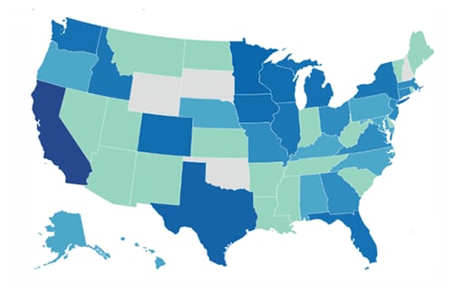
COVID-19 NWSS Wastewater Monitoring in the U.S.
Region with the highest wastewater viral activity level for COVID-19:
From DB
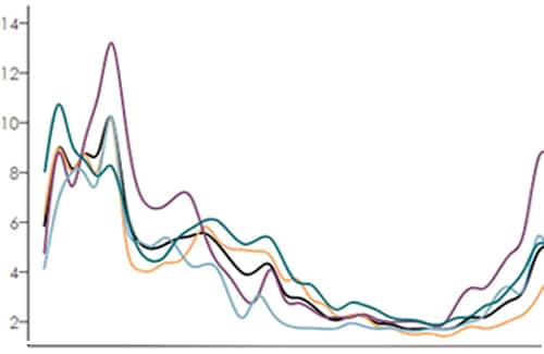
This chart shows national and regional trends of SARS-COV-2 viral activity levels in wastewater.
This chart shows national and regional trends over time of the levels of SARS-CoV-2 (the virus that causes COVID-19) activity levels present in samples of wastewater taken from sites across the United States. Wastewater monitoring can detect viruses spreading from one person to another within a community earlier than clinical testing, and before people who are sick go to their doctor or hospital. It can also detect infections without symptoms. If you see increased Wastewater Viral Activity Levels of SARS-CoV-2, it might indicate that there is a higher risk of infection. See how to protect yourself from respiratory viruses like COVID-19.
The Wastewater Viral Activity Level shows changes in SARS-CoV-2 virus levels in wastewater compared to the baseline level for each wastewater treatment plant. National and regional data represent the median values across all wastewater treatment plants in the respective area. The Wastewater Viral Activity Levels are categorized into minimal, low, moderate, high, or very high as follows:
- Less than 1.5 – Minimal
- Greater than 1.5 and up to 3 – Low
- Greater than 3 and up to 4.5 – Moderate
- Greater than 4.5 and up to 8 – High
- Greater than 8 – Very High
For more information, see Data Methods.
States and territories are grouped into the following U.S Census Bureau regions:
- West: Alaska, Arizona, California, Colorado, Guam, Hawaii, Idaho, Montana, Nevada, New Mexico, Oregon, Utah, Washington, Wyoming (N=14)
- Midwest: Illinois, Indiana, Iowa, Kansas, Michigan, Minnesota, Missouri, Nebraska, North Dakota, Ohio, South Dakota, Wisconsin (N=12)
- Northeast: Connecticut, Maine, Massachusetts, New Hampshire, New Jersey, New York, Pennsylvania, Puerto Rico, Rhode Island, Vermont (N=10)
- South: Arkansas, Alabama, Delaware, District of Columbia, Florida, Georgia, Kentucky, Louisiana, Maryland, Mississippi, North Carolina, Oklahoma, South Carolina, Tennessee, Texas, Virginia, West Virginia (N=17)