
|
|
Volume 1:
No. 4, October 2004
TOOLS & TECHNIQUES
Considerations for Using a
Geographic Information System to Assess Environmental Supports for Physical
Activity
Dwayne E. Porter, PhD, Karen A. Kirtland, PhD, Matthew J. Neet, MPH,
Joel E. Williams, MPH, Barbara E. Ainsworth, PhD, MPH
Suggested citation for this article: Porter DE,
Kirtland KA, Neet MJ, Williams JE, Ainsworth BE. Considerations for using a
geographic information system to assess environmental supports for physical
activity. Prev Chronic Dis [serial online] 2004 Oct [date cited].
Available from: URL:
http://www.cdc.gov/pcd/issues/2004/
oct/04_0047.htm.
Abstract
The use of a geographic information system (GIS) to study environmental
supports for physical activity raises several issues, including acquisition and development, quality, and analysis.
We recommend to public health professionals interested in using GIS
that they investigate available data, plan for data development where none
exists, ensure the availability of trained personnel and sufficient time, and
consider issues such as data quality, analyses, and confidentiality.
This article shares information about data-related issues that we
encountered when using GIS to validate responses to a questionnaire about
environmental supports for physical activity.
Back to top
Introduction
Beginning with John Snow’s 19th-century use of maps to track
the source of a cholera epidemic in London, maps have been an instrumental
tool in addressing public health concerns (1). A geographic information
system (GIS) is a tool that facilitates the development of dynamic maps with
data integration and analysis techniques focused on public health issues
such as environmental supports for physical activity (PA).
Environmental supports for PA have been well documented in the public
health community (2). PA levels have been positively associated with the
presence of environmental features, including sidewalks (3) and recreation
facilities (4,5). Most studies that have identified associations of the
environment to PA have used self-report data (2). Few PA studies have
obtained objective measures of the environment using GIS (6,7). For example,
GIS was used to assess elevation measures to compare terrain with trail use
(6). Rather than relying on self-report measures of the environment,
researchers using GIS can compare PA behavior to the actual environment (7).
GIS can be used to manipulate, analyze, and present information linked to
a geographic location (8). One intriguing aspect of this technology is the
limited knowledge of its capabilities and limitations in the public health
field (9,10). We recently used GIS to validate responses to a questionnaire
about environmental features (e.g., sidewalks, streetlights) believed to be
related to PA (7). (The complete survey is available from: URL:
http://prevention.sph.sc.edu/tools/docs/Env_Supports_for_PA.pdf*.) The intent of this essay is to share information about
data-related issues we encountered, including data acquisition and
development, data quality, and GIS-based data analysis.
Data acquisition and development
Challenges of acquiring and developing GIS data include knowledge of
resources for obtaining data; agreement issues between data owner and user;
knowledge of methods to develop data such as using a global positioning
system (GPS) or geocoding; creation of attributes that describe the data;
and trained personnel and sufficient time to conduct these activities.
Acquiring data for GIS can range from downloading Internet files to
contacting government offices or companies for use of their data, which can
be time consuming. In our study, we, with no formal written agreement, acquired data on roads, waterways, and
public facilities from state agencies.
However, we entered into written agreements with the local police
departments to obtain locations of crime incidents. When we collected data
on streetlights, we found that one utility company maintained data for
locations of county-owned streetlights and required no written agreement
and another utility company maintained data for locations of city-owned
lights and required a written agreement. The written agreement was intended
to ensure that the data were not used in a manner unacceptable to the data
provider. Furthermore, one company was local and had data available only on
paper maps, while the other company was located in a different state and
maintained digital data.
When data did not exist, we used GPS to map environmental features such
as trails and sidewalks. Although we preferred personnel to have preexisting
knowledge of how to use GPS, we had to train some personnel, which was
time consuming. When data existed only in a hard-copy form (e.g., paper
maps) and GPS was not a reasonable alternative, information available from
other sources was manually converted (e.g., scanning images) into a digital
form for use in GIS. For example, county-maintained streetlights were
manually digitized into GIS because only paper maps were available and it
was not practical to apply GPS to more than 15,000 streetlights.
Another important technique in determining locations of environmental
supports for PA and residential locations of survey respondents was the
method of geocoding. Geocoding maps an address to geographic coordinates
using a georeferenced street database (11). In our study, we geocoded
addresses of crime incidents, unattended dogs, places of worship, schools,
and respondents. Time constraints and knowledge of geocoding techniques are
factors to consider when planning a GIS project. For example, we geocoded
1112 residential addresses but more than 20,000 crime addresses.
Once data on location of environmental supports for PA and respondents
were collected and integrated into GIS, we obtained attributes about those
features. Attributes are characteristics about the environment or
individuals that are linked to a spatial feature (e.g., location of
facility, respondent). Some of the environmental characteristics of our
study were traffic volume, condition of sidewalks and recreation facilities,
and opportunities for PA in schools and places of worship. We acquired
annual average daily traffic counts from the South Carolina Department of
Transportation (SC DOT) and conducted in-person audits to collect data
related to sidewalk maintenance and public recreation
facility conditions. We contacted schools and places of worship to determine if
opportunities for PA were available to the public. We then linked attributes
to their features (e.g., locations of roads, sidewalks, recreation facilities,
schools, places of worship). Finally, survey responses were linked to the
residential location of each survey respondent. In all data-collection
activities, trained personnel and time availability were key elements in
successfully obtaining or developing data.
Data quality
The expression “garbage in, garbage out” is true of GIS: if data put into
the system are inaccurate or incomplete, the GIS product will be of minimal
value. GIS data quality concerns include spatial scale and spatial errors
(10), incomplete data (10), temporal issues (10), and incomplete or
erroneous attributes (12). In the best-case scenario, metadata should be
available for all data to provide users enough information to determine data
quality. In our study, the utility company that was located in a different
state provided the city streetlight data, which was saved in their local
coordinate system. We then reprojected the data to match the coordinate
system of the study area. Road files used for geocoding addresses can also
be potential sources of inaccuracy (10). Figure 1 shows a variation of
approximately 20 meters between locations of an address mapped using three
different road files (13). Also, road files are limited to road names and
numbers; therefore, addresses without that type of information (e.g., rural
routes) cannot be accurately geocoded. When an address cannot be mapped, the
user needs to determine if the problem results from an incomplete road file
or an inaccurate address (10,14). Temporal components of data should also be
considered (10). A TIGER (Topologically Integrated Geographic Encoding and
Referencing) road file, available through the 1990 U.S. Census Bureau
survey, may be an inaccurate representation of current roads, because roads may
have changed or new roads may have been created. Inaccuracies may be found with other nonstatic
types of data, such as digital elevation models and aerial photographs.
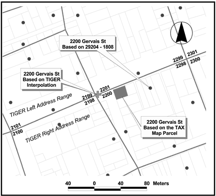
Figure 1. Geocoded locations of a single address using three different road
files, illustrating a potential source of error in geographic information
systems (GIS) (13).
Finally, data represented by spatial coordinates on a map in GIS also
have additional information stored in an attribute table. Attributes can
represent crucial information that is required in data analyses. In our
study, the crime database contained features that were mapped to show the
location of where a crime had occurred, but the attribute table contained
characteristics about that feature, including type of crime and when the
crime occurred. Because attributes provide important information about
features, we checked the attribute data to ensure accuracy and completeness.
For example, SC DOT traffic counts, which were attached as attributes to the
road file, represented only state-maintained roads. County-maintained roads
did not have traffic counts. Crime data entries were encoded and included
administrative calls. Thus, we had to decode the data to reveal only crime
incidents.
Data analyses
GIS-based data analyses in our study included creating neighborhood
buffers and community road networks, interpolating traffic counts, and
querying and exporting attributes to determine distributions of crime data. One
goal of our study was to compare perceptions of the environment to the
actual environment at the neighborhood and community levels. To make these
comparisons, we quantified neighborhood and community environments using
GIS-based spatial analyses and network analyses (15,16). Researchers
describing geographic environments measured with GIS-based tools should
explain the differences between distance defined “as the crow flies” using
spatial analyses and distance defined by a road network using network
analyses. In the PA study, we used a half-mile buffer encircling the survey
respondent’s address to represent the respondent’s neighborhood. In
contrast, we used a 10-mile buffer encircling the respondent’s address, with
the buffer defined and shaped by the surrounding road network, to represent the respondent’s
community.
As part of our process of comparing perceptions of the environment to the
actual environment, we integrated survey responses into GIS. Figure 2
provides an example of a respondent’s neighborhood and proximity of
recreation facilities and sidewalks. We compared this actual environment to
the survey respondent’s perception of it. These repetitive comparisons can
be made manually, but it may take months. A computer program generated in
GIS-supporting languages (e.g., Avenue, Visual Basic) may produce results
within a short period of time, saving time and money.
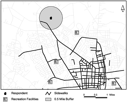
Figure 2. Using a half-mile buffer to represent a neighborhood around a survey
respondent’s home address, GIS can be used
to identify a sidewalk or recreation facility in a survey respondent's
neighborhood.
We made some comparisons based on the presence or absence of an
environmental feature, but we made others based on features that required a
scale of measurement, such as heavy or light traffic based on traffic counts or
safe or unsafe neighborhoods based on crime data. We used interpolation
techniques to estimate traffic counts along county-maintained roads, which
were not counted by SC DOT. Although interpolation techniques have been
traditionally used in spatial-based analyses (17), they are not so familiar
to researchers interpolating spatial data. Thus, trained and experienced
personnel should be considered when using interpolation techniques.
To designate environments as safe or unsafe, we investigated geographic
distributions of various types of crimes. Using codes created by the Federal
Bureau of Investigation (18), crime incidents were identified by
degree of violence. We examined distributions of violent and nonviolent
crime incidents to classify neighborhoods as safe or unsafe. Other measures
of the social environment, such as questions about trustworthy neighbors or
pleasant neighborhoods, were difficult to assess using GIS. However, we were
able to use mean survey responses to social questions to designate pleasant
neighborhoods using GIS.
Researchers also need to ensure that the development and use of GIS data
are appropriate for their research question. In our study, we developed GIS
data to validate survey responses about the presence or absence of
environmental supports for PA. However, researchers may also be interested
in analyzing associations of GIS measures to PA. In this case, GIS measures
may need to go beyond the presence or absence of features and take into account
quantitative measures such as miles of trails and sidewalks or number of
recreation facilities.
Although GIS is a powerful tool for assessing individual and
environmental features and characteristics, there are limitations in using
this technology, especially for public health studies. Available data that
can be used in GIS may be incomplete or inaccurate, and sometimes data are
not available. Other types of limitations include the human and monetary
resources required to incorporate GIS into a public health study. For
example, we initially believed that validating survey responses in the PA
study using GIS would be straightforward and simple. Ultimately, five
additional personnel were hired to assist the research team. A university
lawyer was involved to ensure confidentiality of shared data. It took years
to collect and interpret the GIS data, instead of the initially projected one
year. In addition, the costs to complete the study were nearly double costs originally budgeted. Thus, insufficient knowledge of required time,
personnel, or money will limit the addition of GIS into a public health
study.
In our study, we had to consider data-related issues involving
acquisition, development, quality, and analysis. We also had to consider
issues of confidentiality and agreements with data providers. The
Table
summarizes key points researchers should consider when using GIS. By integrating
many different types of data into GIS, we validated survey responses about
environmental supports for PA. As long as users understand the capabilities
and limitations of both GIS and spatial data, GIS can be a valuable tool to
support improved community-level assessment and understanding of the
relationships between PA and the environment.
Back to top
Acknowledgments
The Cardiovascular Health Branch, Centers for Disease Control and
Prevention (CDC) cooperative agreement U48/CCU409664-06 (Prevention Research
Centers Program), funded this study and the CDC Division of Nutrition and
Physical Activity provided administrative support. The authors would like to
acknowledge the assistance of Haifeng Zhang in preparation of this
commentary, constructive comments provided by Steve Hooker, PhD, and Dawn
Wilson, PhD, and our state and local data providers and community partners
in this study.
Back to top
Author Information
Corresponding author: Dwayne E. Porter, PhD, Department of Environmental
Health Sciences, Arnold School of Public Health, University of South
Carolina, Columbia, SC 29208. Telelphone: 803-777-4615. Fax: 803-777-3391. E-mail: dporter@inlet.geol.sc.edu.
Author affiliations: Karen A. Kirtland, PhD, Joel E. Williams, MPH, Prevention Research Center,
Arnold School of Public Health, University of South Carolina (USC),
Columbia, SC; Matthew J. Neet, MPH, Belle W. Baruch Institute for Marine and
Coastal Sciences, USC, Columbia, SC; Barbara
E. Ainsworth, PhD, MPH, Department of Exercise and Nutritional Sciences,
College of Professional Studies and Fine Arts, San Diego State University,
San Diego, Calif.
Back to top
References
- Boulos MN, Roudsari AV, Carson ER.
Health geomatics:
an enabling suite of technologies in health and healthcare. J Biomed Inform 2001;34(3):195-219.
- Humpel N, Owen N, Leslie E.
Environmental factors associated with
adults' participation in physical activity: a review. Am J Prev Med
2002;22(3):188-99.
- Saelens BE, Sallis JF, Frank LD.
Environmental correlates of
walking and cycling: findings from the transportation, urban design, and
planning literatures. Ann Behav Med 2003;25(2):80-91.
- Booth ML, Owen N, Bauman A, Clavisi O, Leslie E.
Social-cognitive
and perceived environmental influences associated with physical activity
in older Australians. Prev Med 2000;31:15-22.
- Brownson RC, Baker EA, Housemann RA, Brennan LK, Bacak SJ.
Environmental and policy determinants of physical activity in the United
States. Am J Public Health 2001;91(12):1995-2003.
- Troped PJ, Saunders RP, Pate RR, Reininger B, Ureda JR, Thompson
SJ.
Associations between self-reported and objective physical
environmental factors and use of a community rail-trail. Prev Med
2001;32:191-200.
- Kirtland KA, Porter DE, Addy CL, Neet MJ, Williams JE, Sharpe PA,
et al.
Environmental measures of physical activity supports: perception
versus reality. Am J Prev Med 2003;24(4):323-31.
- Lang L. GIS for health organizations. Redland (CA): Environmental
Systems Research Institute, Inc; 2000.
- Cohodas M. The GIS equation. Governing 1996;10:67-68.
- Melnick A, Fleming D.
Modern Geographic Information Systems: promise
and pitfalls. J Public Health Manag Pract 1999;5(2):viii-x.
- Richards T, Croner C, Novick L.
Atlas of state and local Geographic
Information Systems (GIS) maps to improve community health. J Public
Health Manag Pract 1999;5(2):2-8.
- Finnie TC, Antenucci JC, Bossler JD, Cowen DJ, Estes JE, Johnson
RD, et al. Spatial data needs: The future of the national mapping
program. Washington (DC): National Academies Press; 1990.
- Cowen, David J. Discrete Georeferencing, NCGIA Core Curriculum in GIScience
[Internet]. Santa Barbara (CA): National Center for Geographic Information
& Analysis; 1997. Available from: URL: http://www.ncgia.ucsb.edu/education/curricula/ giscc/units/u016/u016_f.html*.
- Goss J. We know who you are and we know where you live: the
instrumental rationality of geodemographic systems. Econ Geogr
1995;71(2):171-98.
- Longley PA, Goodchild MF, Maguire DJ, Rhind DW. Geographic information
systems and science. Indianapolis (IN): John Wiley & Sons, Ltd.; 2000.
- Pang Lo C, Yeung AKW. Concepts and Techniques of Geographic
Information Systems. Prentice Hall; 2002.
- Mitchell A. The ESRI Guide to GIS Analysis. Redlands (CA):
Environmental Systems Research Institute, Inc.; 1999.
- Federal Bureau of Investigation.
Uniform Crime Report for the
United States, 1996. Washington (DC): U.S. Department of Justice;
1996. 10 p.
Back to top
Table
 Key
Points to Consider in Using a Geographic Information System (GIS) to Assess
Environmental Supports for Physical Activity Key
Points to Consider in Using a Geographic Information System (GIS) to Assess
Environmental Supports for Physical Activity
| Ensure enough time, money,
and properly trained personnel are budgeted. |
| Hire trained
personnel who can create or collect and evaluate the appropriateness of
spatially related data. |
| Determine if a written
agreement is required with the provider of GIS data. |
| Adhere to issues of
confidentiality when spatial data are considered sensitive (e.g., locations of crime incidents and
private residences). |
| Seek legal counsel when
obtaining certain types of GIS data through private companies. |
| Ensure available metadata is
created for acquired GIS data so that data quality can be determined. |
| Obtain accurate and complete
road files for geocoding — address locations can vary with
different data sources. |
| Be aware that data sources
will vary in completeness, scale, and accuracy and may include spatial or
temporal problems. |
| Differentiate between
distances measured “as the crow flies” and distances measured along road
networks. |
| Consider GIS usefulness in
comparing what is actually in the environment to what is perceived by the
individual to be in the environment. |
| Develop GIS data that
are
appropriate to the research question. |
| Keep in mind that GIS is
effective in bringing together disparate data sources to measure a variety
of environmental supports for physical activity. |
| Realize that GIS does not
differentiate between good and bad data — therefore, GIS can make attractive
but inaccurate products! |
|
*URLs for nonfederal organizations are provided solely as a
service to our users. URLs do not constitute an endorsement of any organization
by CDC or the federal government, and none should be inferred. CDC is
not responsible for the content of Web pages found at these URLs.
|
|
