Success Stories - Educating Communities
Florida – Consuming fish safely: Mercury biomonitoring project

What is the problem?
Mercury is a toxin that occurs in the environment naturally and as a result of industrial pollution. Methylmercury is a form of mercury found in some fish and shellfish. It poses a risk to people who consume certain types of fish and shellfish. The greatest risk is to women of childbearing age and to children, who should not eat certain types of fish. Mercury can damage the nervous system of young children and developing fetuses.
Human exposure to mercury through fish consumption is a growing concern in the United States. Areas with high mercury emissions from coal-fired power plants and that have populations who frequently consume fish are of most concern. To help people eat the proper amount and species, they need accurate information about how much and what types of fish to consume.
What did Tracking do?
Researchers evaluated fish eating patterns among women of child-bearing age in Duval and Martin Counties, their research also included mercury biomonitoring. Participants completed a survey about their fish eating habits, knowledge of fish consumption advisories, pregnancy status, demographic and socio-economic information, and mercury exposure history. And each participant provided a scalp hair sample for mercury analysis.
Results showed that women of child-bearing age in Duval and Martin Counties consume more fish than their counterparts in other areas of the United States and that their hair-mercury levels are higher than the participants of the study who do not consume fish. Because of the low local awareness of fish advisories, increased education is needed about the advisories and about mercury exposure among at-risk populations in Duval and Martin Counties.
Improved public health
The Florida Tracking Program created the Fish for Your Health Wallet Card. It contains information about what types and amounts of fish to eat. It encourages women to enjoy the health benefits of certain kinds of fish but also avoid unsafe amounts of mercury. The card lists:
- Species of fish by different categories of mercury content, and
- Suggested amounts of fish to eat each week.
The Florida Tracking Program distributes the wallet cards to county health departments, state fish markets and grocery stores, and to the Florida Medical Association (FMA). The FMA sends the wallet cards to local branches and to physicians’ offices.
Louisiana – Deepwater Horizon (British Petroleum) Oil Spill
![]()
What is the problem?
On April 20, 2010, a drill rig explosion caused about 4.9 million barrels of oil to spill into the Gulf of Mexico. The explosion killed 11 platform workers and injured 17. Marine and wildlife habitats were severely affected, and the fishing and tourism industries of U.S. coastal states were devastated.
What did Tracking do?
The Louisiana Tracking Program has been developing an oil spill response plan in collaboration with CDC/ATSDR*, CDC/NIOSH+, and agencies from other affected Gulf Coast states. Survey- and map-based tracking systems were developed to capture and track health complaints and environmental monitoring results. In addition, the Louisiana Tracking Program worked with the Occupational Safety and Health Administration (OSHA) to make sure that outreach materials were available in several languages and available to those with limited Internet access.
Improved public health
The Louisiana Tracking Program worked with the state health department to notify OSHA about workplace exposures and health complaints from emergency response workers. Interventions were held to educate response workers, residents, and health care providers on topics such as personal protective equipment, seafood safety, chemicals of concern, potential routes of exposure, and associated health effects.
*Agency for Toxic Substances and Disease Registry
+National Institute for Occupational Safety and Health
Louisiana – Addressing concerns from imported drywall
What is the problem?
After Hurricane Katrina, rebuilding throughout the Gulf states greatly increased the demand for drywall. In February 2009, the state health department began getting health complaints from residents who had rebuilt their homes using imported drywall. The health complaints included headaches, respiratory infections, eye irritations, dry coughs, and nosebleeds.
What did Tracking do?
The Louisiana Tracking Program began logging cases from call-in surveys that captured information such as the physical characteristics of the home, exposure duration, and health effects experienced by members of the household. The cases were mapped to assess the magnitude of the health problem and to track locations. State health department staff worked with the U.S. Environmental Protection Agency to identify drywall exposure cases for indoor air testing.
Improved public health
Air monitoring results helped staff identify the chemicals of most concern and develop a public health plan of action. Public health messages provided residents information and ideas on how to reduce exposure and remove tainted drywall from their homes.
Louisiana – Educating private well water users about contamination
What is the problem?
Louisiana has a large number of residential water wells located within one mile of either an operating or abandoned wood preservation or wood treatment facility. No Louisiana law requires private well water testing. This limits the ability to assess potential exposures to chemicals through well water.
What did Tracking do?
In partnership with the Louisiana Department of Environmental Quality and the state’s Safe Drinking Water Program, the Louisiana Tracking staff conducted a pilot project to link environmental, exposure, and health outcome data around wood preservation and treatment sites. The pilot project included:
- Compiling groundwater and drinking water data from areas near 22 inactive wood preservation and treatment facilities.
- Compiling data on bladder, lung, and all-sites cancers in areas surrounding wood preservation facilities.
- Establishing the Private Well Water Education Initiative to register private wells.
Improved public health
As a result of the pilot project, many residents who have private water wells contacted the health department to obtain a list of places where they can test their well water. This should help reduce potential exposures to contaminated well water.
Maine – Educating Residents about a New Risk for Carbon Monoxide Poisoning

What is the problem?
In May 2012, three adults died from carbon monoxide (CO) poisoning after their off-roading vehicle became stuck in a mudbog in central Maine. While CO poisoning has long been a public health concern in Maine, off-roading was not among the list of potentially risky activities included in the state health department’s public education efforts about preventing CO poisoning.
What did Tracking do?
Immediately responding to the deaths, Maine Tracking Program staff used data from their case-based CO poisoning surveillance system to identify a similar event that occurred in 2010. Using information about the two events, the tracking program identified off-roading as a more significant risk for CO poisoning than previously thought. Within a day of the 2012 deaths, tracking staff began educating reporters about CO poisoning, providing them guidance about preventing CO poisoning while off-roading to include in the ongoing news coverage of the deaths.
Improved public health
A few weeks following the deaths, the tracking program issued its annual advisory about preventing CO poisoning during summertime activities. This advisory included specific CO poisoning prevention advice about off-roading. These recommendations are now part of Maine’s standard health advisory issued each spring.
Maryland – Answering community concerns about cancer
![]()
What is the problem?
Community concerns about cancer and potential links to environmental hazards occur relatively frequently in Maryland. Before the Maryland Tracking Program began in 2002, most concerns about cancer and the environment were addressed only by the Maryland Cancer Registry and possibly local health departments. Maryland had no systematic way to respond to frequently asked questions from individuals, groups, and communities about cancer and the environment.
What did Tracking do?
The Tracking Program, working with the Maryland Cancer Registry, geocoded all residential addresses in the Registry. Now the Maryland Cancer Registry can accurately show cancer data in maps and carry out geospatial analyses of cancer information. Also, for the first time, there is an established process for evaluation of cancer concerns in Maryland. The new process involves a coordinated response that includes the Maryland Cancer Registry, the Center for Environmental Health Coordination, the Maryland Department of the Environment (MDE), and local health departments and is now available on the Tracking Program’s Web site.
Improved public health
The Tracking Program has worked with the Maryland Cancer Registry on two major cancer investigations, one in Poolesville and another in Frederick. The first looked at concerns about cancer and drinking water; the second involved concerns about cancer in a community. In both cases, the Maryland Tracking Program provided maps showing the geographic distribution of cancer and geo-statistical analyses of the cancer cases. The results of these two investigations were presented at community meetings. To date, there is no evidence of cancer clusters, but experts were able to answer questions from community residents.
Massachusetts – Examining the relationship between cancer rates and proximity to a nuclear power plant
![]()
What is the problem?
Franklin County residents expressed concern about the number of new cases of cancer in their towns because they are close to the Vermont Yankee Nuclear Power Plant. This plant is less than 5 miles from the Massachusetts state border. Nuclear power plants produce ionizing radiation. Exposure to radiation has been associated with certain cancers such as bone, brain, central nervous system, thyroid, leukemia, and multiple myeloma.
What did Tracking do?
The tracking program reviewed available cancer data for five cancer types with possible associations to radiation. The data covered a span of 23 years for 17 Massachusetts communities located within a 20-mile radius of the power plant. They did not find any unusual patterns for cancer in Franklin County.
Improved public health
The Massachusetts Tracking Program used data from the state’s tracking network to address community concerns about cancer risks. They shared their findings with the community in a report. Over time, the tracking program has noticed a decrease in the number of questions they receive related to this power plant. Because data are readily available on the tracking network, answering inquiries like this one take less time and resources. This ensures that public health responses are efficient and economical.
Minnesota – Preparing for Extreme Heat Events

What is the problem?
Extreme heat events, or heat waves, are the most common cause of weather-related deaths in the United States. In Minnesota each year, heat-related illnesses lead to hundreds of emergency department visits and hospital stays. Planning successful prevention and response activities for extreme heat events can be difficult for public health agencies when they do not have a clear picture of who is most at risk.
What did Tracking do?
The Minnesota Tracking Program analyzed data on heat-related illnesses and deaths to inform health professionals about groups most at risk during extreme heat events. They found surprising new information, including:
- 15- to 34-year-olds are an at-risk age group, in addition to people aged 65-years and older.
- Rates of hospital stays and emergency department visits were higher in greater Minnesota compared to the 7-county metropolitan area that includes the Twin Cities.
State and local health professionals used the tracking data to develop and update maps showing areas with at-risk populations. The maps show which areas need support to prepare for heat waves.
Improved public health
Health agencies across Minnesota now have a clearer understanding of the people most at risk for illness or death from extreme heat. Each summer, they use the data to focus outreach and planning efforts. Then they use the data to evaluate the effectiveness of their prevention and response efforts and to monitor trends of heat-related illness over time.
New Mexico – A team approach to addressing cancer concerns
What is the problem?
A resident called the New Mexico Department of Health to express concern about a potential increase in rates of tobacco-related cancers in the community. The health department put together a team to investigate and respond to the caller’s concerns. Team members came from the state tracking program, the Chronic Public Health Disease Prevention Bureau, and the NM Tumor Registry.
What did Tracking do?
The New Mexico Tracking Program provided census-tract level data from the state tracking network to the team. The team then looked at cancer rates and risk factors for the caller’s neighborhood.
Improved public health
As a result of the investigation, the team provided a clear picture to the caller and the community about tobacco-related cancer risk in the area and the people most affected.
Without the tracking network data, the team could not have provided specific cancer information. Also, responding to the caller’s concerns would have taken much longer.
New Mexico – Improving emergency response in rural areas
What is the problem?
Propane gas leaks can cause unsafe levels of carbon monoxide (CO) to build up inside a home. People—and especially children— who breathe in CO can become very sick. When emergencies like CO poisonings happen in rural parts of New Mexico, providing timely health services can be difficult. Often, rural areas do not have the staff or special skills to respond as quickly as in other areas.
What did Tracking do?
New Mexico’s tracking program has developed educational resources to use during CO emergencies. Patient education materials on CO exposure and poisoning and other topics are available on the program’s tracking Web site. Also, tracking staff are available to consult with health care workers across the state about health education and outreach.
Improved public health
Because of the state tracking program’s resources, health care workers across the state can better serve the emergency needs of rural residents. Health care workers can access materials any time of the day to educate their communities about:
- Propane gas safety,
- CO exposures, and
- Associated health effects.
Without the state tracking program, rural communities would not have access to such high quality materials.
New Hampshire – Reducing radon exposure
![]()
What is the problem?
Radon is a natural gas that has no color or smell. New Hampshire’s environment creates more radon than most states. As a result, more people are exposed. Radon causes more than 100 lung cancer deaths in New Hampshire each year. Testing for radon is cheap and could help stop these deaths. Still, more than 250,000 homes in high radon risk areas have not been tested.
What did Tracking do?
The New Hampshire Tracking Network worked with the New Hampshire Department of Environmental Services Radon Program to create a radon testing media campaign. The campaign ran in January for Radon Awareness Month. An issue brief was posted on the New Hampshire Tracking Network website. It described the link between radon risk and radon testing behavior. The New Hampshire Department of Environmental Services sent out a news release to offer free radon test kits to the community.
Improved public health
The New Hampshire Department of Environmental Services gave out thousands of free radon test kits to residents. The New Hampshire Environmental Public Health Tracking Program responded to requests on how to reduce radon exposure. The Tracking Program continues to hold radon awareness events with public health officials and in the community. Plus, the Tracking Program now uses its Environmental Health Data Integration Network to track and check for trends in lung cancer cases.
New York – Answering Concerns about Neighborhood Air Quality

What is the problem?
The Buffalo Peace Bridge Plaza spans the Niagara River and connects New York State to Ontario, Canada. Lots of traffic passes over the bridge every day. Residents in neighborhoods on the New York side of the bridge worried that the planned future expansion and improvements of the Peace Bridge Plaza would cause an increase in air pollution from additional traffic and lead to respiratory health problems like asthma attacks.
What did Tracking do?
The New York State Tracking Program partnered with state environmental and transportation agencies to investigate residents’ concerns. They examined air quality and related health concerns in neighborhoods surrounding the Peace Bridge toll plaza. The tracking program analyzed zip code level data on asthma-related hospital stays and emergency department visits in the neighborhoods surrounding the Peace Bridge. They also studied and mapped air quality data, traffic counts, and socioeconomic data for the same areas. The data showed that neighborhoods surrounding the bridge were not at increased risk for asthma-related health problems from air pollution.
Improved public health
The state tracking program and partners presented the information to concerned residents and issued a report. They shared information about how current air quality in the neighborhoods around the bridge was not contributing to asthma problems among people living there. Also, they educated neighborhood residents about how the new construction would result in improved air quality over time, despite a possible increase in traffic.
New York – Tracking carbon monoxide risk factors to prevent poisonings
![]()
What is the problem?
Many New Yorkers use portable generators when the power goes out. Generator use increases the risk of carbon monoxide (CO) poisoning. Little information is available about how many households use portable generators during power outages. Also, the number of households that have properly installed and maintained CO alarms is unknown.
What did Tracking do?
To learn more about portable generator and CO alarm use, New York State’s Tracking Program added questions to the 2008 New York State Behavioral Risk Factor Surveillance System survey. The Tracking Program collected and analyzed survey results that showed nearly 20% of state residents and more than 33% of residents living outside major cities had a portable generator. Almost 30% of all residents did not have a CO alarm in their homes.
Improved public health
The state department of health used the tracking program information to identify areas most at risk for CO poisoning. The state worked with local health departments and other partners to distribute generator safety posters and CO poisoning-prevention door hangers to area residents. The survey data will track the success of the generator campaign. The data will also show whether people follow the 2009 state law mandating CO alarms in all homes.
New York – Assisting with public health investigations
What is the problem?
A citizen asked the health department to look into respiratory disease in communities near an upstate New York coal-fired power plant. Getting, processing, and evaluating the necessary data can take a long time. Community members often want this information quickly.
What did Tracking do?
Using data gathered through the state Tracking Program, the health department quickly was able to find the rates of hospital stays for asthma and other respiratory diseases in areas downwind of the power plant. The results showed fewer than expected hospital stays for asthma, bronchitis, and chronic obstructive pulmonary disease.
Improved public health
The Tracking Program data on respiratory-related hospital stays were readily available. The health department investigated respiratory disease in the area and efficiently and quickly provided findings to local residents and to the media.
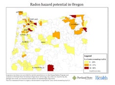
Oregon – Increasing Awareness of and Testing for Radon

What is the problem?
Radon is the second leading cause of lung cancer and is the leading environmental cause of cancer deaths in the United States. Radon is a colorless, odorless, tasteless radioactive gas. Testing is the only way to know if radon levels are high in a building or home. In 1993, the U.S. Environmental Protection Agency identified Oregon as having low to moderate levels of radon. However, recent data show that some areas of the state have high radon levels. The state needed more accurate data on radon hazards to promote testing.
What did Tracking do?
The Oregon Tracking Program and partners developed maps showing radon hazards for areas smaller than counties. Tracking staff used these maps to support public education to encourage in-home radon testing during January 2013, Radon Action Month. They published the radon maps on the health department’s Radon Program web pages and on Oregon Tracking’s Facebook page. They sent news releases to media outlets announcing the maps and providing information about radon testing.
Improved public health
Television news coverage and two front-page articles in The Oregonian newspaper about the maps helped raise public awareness of radon hazards and encourage radon testing. Following the media coverage, monthly average visits to the Radon Program’s web pages tripled. Data from the American Lung Association (ALA) of Oregon showed that they sold nearly 300 test kits during the first day the front page Oregonian article ran. Within three days, ALA sold more radon test kits online than they did in the entire year of 2012. Increases in radon testing likely will lead to more people taking steps to decrease the amount of radon they come in contact with.
Pennsylvania – Arsenic concentrations in groundwater
![]()
What is the problem?
Pennsylvania has a large rural population dependent on private wells for drinking water. Some of these wells pull groundwater that contains high levels of arsenic. Several studies have suggested that long-term exposure to arsenic contamination in groundwater increases the risk of developing bladder, kidney, liver, bronchus and lung, and prostate cancer.
What did Tracking do?
In order to better evaluate distribution of arsenic in the state’s ground water, USGS, Pennsylvania Department of Health, and Pennsylvania Department of Environmental Protection began surveillance in 2005 to relate arsenic concentrations in major aquifers. Aquifers are a formation, group of formations, or part of a formation that contains sufficient saturated, permeable material to yield significant quantities of water to wells and springs. Of 169 domestic wells and springs tested, arsenic was detected in 18. Of these, 10 wells had total arsenic levels greater than the U.S. Environmental Protection Agency (EPA) maximum containment level.
Improved public health
Pennsylvania’s Tracking Program counseled families in high risk areas to use bottled water and referred one person to a doctor because of extremely high arsenic levels. Also, doctors were advised to provide arsenic tests to residents in areas where severely elevated arsenic concentrations had been identified.
South Carolina – Making environmental health data accessible to everyone
What is the problem?
Environmental public health data are often difficult to explain in plain language. Public health and environmental professionals use technical terms to describe such data. But if information is too hard to understand, people will not use South Carolina’s Tracking Network.
What did Tracking do?
South Carolina’s Environmental Public Health Tracking Program is working toward showing and describing data simply. For example, a section of each topic area on the Web site will use everyday examples to describe complex scientific concepts.
Improved public health
People are more likely to use easy-to-understand information, tools, and data. Armed with knowledge, people can make better decisions about reducing health risk and improving overall health. Encouraging use of the state tracking network may increase awareness about environmental health issues. It might also help to explain why the state needs to take certain actions to protect the environment.
South Carolina – Sharing information about the coastal environment
What is the problem?
South Carolina’s large, densely populated coastal area attracts tourists year round. Currently, no one resource informs people about all coastal area issues such as beach conditions and closures.
What did Tracking do?
The South Carolina Tracking Program partnered with state and federal agencies to develop a Coastal EnvironmentExternal Web page. This Web page is now a content area on South Carolina’s EPHT Web site.
Improved public health
Residents and visitors to South Carolina’s coastal area now have access to information such as:
- Real-time weather,
- Environmental advisories and closures,
- Beach conditions, and
- Marine animal diseases.
This information helps residents and visitors better understand how the state’s coastal environment may affect travel plans and health.
Utah – Lowering exposure to arsenic from private well water
![]()
What is the problem?
Some Millard County residents use private wells for cooking and drinking water. The Health Hazard Assessment team of the Utah Department of Health confirmed that in the Delta Conservation Districts, many of the private wells had arsenic concentrations high enough to be an urgent public health hazard.
What did Tracking do?
The Health Hazard Assessment team used drinking water data from the Utah Tracking Network to assess health effects in residents of Millard County caused by drinking arsenic- contaminated water from private wells.
Improved public health
Due to the high levels of arsenic found in this study, the Health Hazard Assessment team recommended that well water in this area not be used for drinking or cooking. They also suggested that residents of the area purchase and install water systems to reduce arsenic exposure in the community. Arsenic levels in water will be monitored until amounts are at levels that are not harmful to human health.
Utah – Addressing a cancer cluster concern
What is the problem?
A cancer cluster disease specialist (epidemiologist) with Utah’s Tracking Program received an inquiry from a concerned resident about a possible cancer cluster in her neighborhood. The resident requested a study of the rate of female thyroid cancer in the past ten years in Tooele County. She named the Energy Solutions landfill as a possible source of environmental radiation exposure.
What did Tracking do?
The cancer cluster epidemiologist compared rates of thyroid cancer in the area to statewide rates, over five year periods. The epidemiologist used the secure Utah Tracking Network’s data as well as the Rapid Inquiry Facility (RIF), a mapping and analysis tool used by the Tracking Program.
Improved public health
The epidemiologist analyzed the data from the tracking program and did not find enough evidence to prove that a thyroid cancer cluster exists among women ages 20-54 in Wasatch, Tooele, and Box Elder counties. Utah’s Tracking Network helped the epidemiologist provide a much quicker response to citizens’ concerns than was previously possible.
Utah – Reducing exposure to lead
What is the problem?
The Eureka Valley was heavily mined from the 1870s to 1965. Several large mine waste rock piles are located on the south side of the town of Eureka, close to homes and businesses. Mining activity and housing construction spread mine waste throughout the town. The mine waste exposed many residents to lead from the Eureka Mills Superfund site.
What did Tracking do?
Blood lead data available in the Utah Tracking Network showed highly elevated blood lead levels in children in Eureka. Soil sampling by the U.S. Environmental Protection Agency and the Utah Department of Environmental Quality also showed elevated levels of lead in soil in this community. These data resulted in an emergency cleanup of the area.
Improved public health
During the cleanup period, the Health Hazard Assessment team (HHA) and the Blood Lead Poisoning Prevention Program conducted free quarterly blood lead testing and provided education to the community. Since cleanup began, fewer children have shown signs of elevated blood lead levels. Now blood lead testing frequency has been reduced from every three months to once a year. The Utah Tracking Program with the Central Utah Public Health Department, Utah Department of Health, and the HHA team will continue blood lead testing for children living in Eureka until 2013.
Washington – Helping Communities Connect Air Pollution Control and Improved Health
![]()
What is the problem?
For American Indians and Alaska Natives in Washington, asthma rates are much higher than the state average. These cases are also less likely to be well controlled. Reducing asthma triggers is a key step in preventing asthma attacks. Smoke can trigger an asthma attack and non-certified wood burning stoves are a major source of smoke in some communities. However, persuading community leaders to address smoke from non-certified woodstoves can be very hard.
What did Tracking do?
The Washington Tracking Network partnered with the Asthma Program at the Department of Health to find out where wood burning stoves- especially non-certified stoves – were being used. The data showed that wood burning was common in many communities, but scientists were most concerned about the high use of non-certified stoves in tribal communities where asthma rates were also high. They met with tribal leaders about wood stove use and highlighted how indoor and outdoor smoke from wood stoves can trigger problems for people with asthma.
Improved public health
After seeing the data about wood stove use and how wood smoke can trigger asthma, tribal leaders began to mobilize and motivate stakeholders around their action plan for managing smoke in their communities.