Success Stories - New Stories
California – Preventing Exposures to Nitrates in Drinking Water

What is the problem?
Nitrate-contaminated drinking water can lead to serious illness in infants. Also, exposure to nitrates has been associated with certain cancers and adverse reproductive outcomes, including various birth defects. In California, some communities are at higher risk for having nitrate contamination in their drinking water. Because there was no statewide digital map of the areas served by drinking water systems, identifying communities at higher risk for nitrate exposure has been difficult. Moreover, the state had no central location for gathering this information.
What did Tracking do?
The California Tracking Program created a Web-based tool to help water systems create digital maps of the areas they serve. Prior to this effort, many systems only had paper maps. The tracking program’s water tool has received information for public water systems that serve almost 90% of the state’s total population. With this information, users can also identify communities that may be using unregulated private wells, which are also at high risk for nitrate contamination.
Improved public health
The University of California at Davis, on behalf of the state Water Resources Control Board, used data from the water tool and other sources in a report to the state legislature. The report identified communities most exposed to nitrate contamination in drinking water and proposed potential remediation solutions. Findings and recommendations in the report have led to prevention, monitoring, training, and funding activities in high risk areas.
California – Identifying Exposures to Air Pollution from Traffic
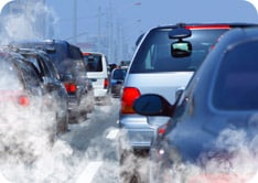
What is the problem?
Air pollution from traffic is associated with a variety of health problems. Researchers and public health workers use data on traffic to estimate air pollution and to look at the relationship between traffic pollution and health. However, traffic data can be difficult to access and use.
What did Tracking do?
The California Tracking Program developed a traffic tool to make it easier to access and use CalTrans traffic data for public health activities. People can use the tool to calculate a range of traffic features, such as the average number of vehicles traveling near a location per day. Users of the tool can find out how much traffic passes through any geography, such as a zip code, neighborhood, or another custom area around a specific address. Researchers can compare data from the traffic tool with health data from the CA Tracking Network or other sources to understand better the possible links between air pollution and health.
Improved public health
Several agencies have used the traffic tool to protect and improve public health. For example, the Bay Area Air Quality Management District uses the traffic tool to determine if a proposed project will increase risks of exposure to traffic pollutants. And the CA Environmental Protection Agency used the traffic tool to identify locations more likely to be exposed to pollution from traffic. The agency added this information to its screening tool which identifies communities likely to be affected most by environmental exposures and poor health.
Florida – Fostering Asthma-friendly Schools

What is the problem?
In 2012, about 20% of middle and high school students in Florida had been diagnosed with asthma. Asthma is a leading cause of missed school days. Uncontrolled asthma can affect students’ grades and limit their involvement in school activities. Schools can play an important role in helping students control and manage their asthma. For example, they can limit students’ exposure to outdoor air pollution that can trigger asthma attacks. Schools can use the U.S. Environmental Protection Agency’s free AirNow.gov alerts to plan activities when air quality is poor. However, the Florida Tracking Program found that few schools use the alerts.
What did Tracking do?
The Florida Tracking Program partnered with the state asthma program to increase the use of the AirNow alerts across the state, especially in schools. Together, they created a process to recognize schools and childcare centers that support asthma-friendly environments. Schools must register to receive AirNow alerts, and meet other criteria, to be considered for this voluntary recognition.
Improved public health
By April 2013, 7 childcare centers and about twelve K-12 schools had received the Asthma-Friendly School Recognition. As more schools are recognized, thousands of children will be attending schools that are better prepared to deal with poor air quality conditions. This will lead to healthier environments for kids with asthma in Florida.
Maine – Educating Residents about a New Risk for Carbon Monoxide Poisoning

What is the problem?
In May 2012, three adults died from carbon monoxide (CO) poisoning after their off-roading vehicle became stuck in a mudbog in central Maine. While CO poisoning has long been a public health concern in Maine, off-roading was not among the list of potentially risky activities included in the state health department’s public education efforts about preventing CO poisoning.
What did Tracking do?
Immediately responding to the deaths, Maine Tracking Program staff used data from their case-based CO poisoning surveillance system to identify a similar event that occurred in 2010. Using information about the two events, the tracking program identified off-roading as a more significant risk for CO poisoning than previously thought. Within a day of the 2012 deaths, tracking staff began educating reporters about CO poisoning, providing them guidance about preventing CO poisoning while off-roading to include in the ongoing news coverage of the deaths.
Improved public health
A few weeks following the deaths, the tracking program issued its annual advisory about preventing CO poisoning during summertime activities. This advisory included specific CO poisoning prevention advice about off-roading. These recommendations are now part of Maine’s standard health advisory issued each spring.
Massachusetts – Investigating Parents’ Concerns about Childhood Cancer

What is the problem?
In Winchester, MA, unusually heavy rains can cause the Aberjona River to rise several feet. The river water spills over onto the ball field and playground areas of Ginn Field, a neighborhood park, and leaves behind sediment. Residents worried the sediment might contaminate the surface soil in the park. They also had concerns about herbicide applications on the field. Because of these issues, parents feared that their children might get cancer from playing in the park.
What did Tracking do?
At the request of concerned residents and the Winchester Board of Health, Massachusetts Tracking staff investigated parents’ concerns about childhood cancer. They used cancer data from the state tracking network to evaluate the pattern of cancer in children. Tracking staff also investigated herbicide use and contaminants in the river water and sediment to determine what children using the field might be exposed to.
Improved public health
In January 2012, the state health department shared its findings in a report to the community and the Board of Health. The report showed that the number of new cases of childhood cancers for Winchester was similar to state trends. This information helped reassure Winchester parents and the Board of Health that touching or unintentionally eating small amounts of soil at Ginn Field would not be expected to make people sick. In addition, the Town of Winchester and the state have begun work to deepen the channel in this section of the Aberjona River as part of a series of projects to lessen the effects of flooding in the area.
Minnesota – Preparing for Extreme Heat Events

What is the problem?
Extreme heat events, or heat waves, are the most common cause of weather-related deaths in the United States. In Minnesota each year, heat-related illnesses lead to hundreds of emergency department visits and hospital stays. Planning successful prevention and response activities for extreme heat events can be difficult for public health agencies when they do not have a clear picture of who is most at risk.
What did Tracking do?
The Minnesota Tracking Program analyzed data on heat-related illnesses and deaths to inform health professionals about groups most at risk during extreme heat events. They found surprising new information, including:
- 15- to 34-year-olds are an at-risk age group, in addition to people aged 65-years and older.
- Rates of hospital stays and emergency department visits were higher in greater Minnesota compared to the 7-county metropolitan area that includes the Twin Cities.
State and local health professionals used the tracking data to develop and update maps showing areas with at-risk populations. The maps show which areas need support to prepare for heat waves.
Improved public health
Health agencies across Minnesota now have a clearer understanding of the people most at risk for illness or death from extreme heat. Each summer, they use the data to focus outreach and planning efforts. Then they use the data to evaluate the effectiveness of their prevention and response efforts and to monitor trends of heat-related illness over time.
Minnesota – Preventing Melanoma

What is the problem?
Melanoma is the most dangerous form of skin cancer. It is one of the most rapidly increasing cancers among Minnesotans. CDC estimates that exposure to ultraviolet (UV) light causes 65-90% of all melanoma. UV light comes from the sun but can also come from tanning beds. Despite the risks for melanoma, tanning bed use remains common in Minnesota.
What did Tracking do?
The Minnesota Tracking Program published interactive maps and charts on their state tracking network showing trends and geographic patterns of melanoma across the state. They also collaborated with the state cancer registry to add county-level melanoma data to MN County Health Tables, a resource used by state and county public health officials to guide program planning and evaluation.
Improved public health
Since making melanoma data easy to find and use, tracking program staff have worked with state programs and other partners, such as the American Cancer Society of MN and the MN Cancer Alliance, to use tracking data to support program and policy initiatives to prevent melanoma. For example, these partners identified reducing the use of artificial UV light for tanning as a key objective in Cancer Plan Minnesota: 2011-2016Cdc-pdfExternal, a framework for preventing and controlling different types of cancer. In addition, tracking data will be used to evaluate the effectiveness of melanoma prevention program and policy initiatives over time.
Minnesota – Evaluating Indoor Smoking Ban Legislation to Protect Residents from Secondhand Smoke

What is the problem?
Secondhand smoke, also known as environmental tobacco smoke, causes cancer and other health problems in both children and adults. To help reduce exposure to secondhand smoke, Minnesota passed Freedom to Breathe legislation in 2007. The legislation banned smoking in almost all indoor public places and indoor work sites, including bars and restaurants. In 2011, some legislators worked to repeal the legislation.
What did Tracking do?
The Minnesota Tracking Program maintains data on secondhand smoke among nonsmokers for the state. Tracking staff analyzed state data to determine if Freedom to Breathe legislation helped reduce residents’ exposures to secondhand smoke. Tracking staff found that since 2007, exposures to secondhand smoke decreased among non-smokers. In addition, children’s exposures decreased by 20% and adults’ exposures decreased by 25%.
Improved public health
Freedom to Breathe legislation remains in place because the tracking program demonstrated that the legislation was associated with a decrease in exposures to secondhand smoke and because there is strong support to keep the smoking bans in Minnesota. In addition, tobacco prevention programs and others have been able to use the tracking data to plan more effective smoking cessation and awareness activities.
New Mexico – Improving Public Health Services

What is the problem?
When people in New Mexico have concerns about cancer and perceived cancer clusters, they can contact several state agencies for help. Sometimes, multiple agencies responded to the same inquiry with different information. This approach used a lot of staff time and resources unnecessarily.
What did Tracking do?
The New Mexico Tracking Program formed the Cancer Concerns Workgroup to provide a coordinated and efficient response to citizen concerns about environmentally-related health conditions and potential cancer clusters. The workgroup included professionals from cancer, chronic disease, and environmental health. With guidance from the tracking program, the workgroup developed a protocol for timely and consistent response and created a secure Cancer Concerns Database to log and track inquiries. The tracking program provides information about cancer risks, prevention messages, and data to use in responses.
Improved public health
Now, state public health agencies can collect cancer concern information and respond to inquiries consistently. Concerned citizens receive a quicker and more thorough response from a team of professionals. Before the protocol, it could take about 2 weeks to draft an initial response to an inquiry. Now the team can prepare a response within 24 hours.
New York – Answering Concerns about Neighborhood Air Quality

What is the problem?
The Buffalo Peace Bridge Plaza spans the Niagara River and connects New York State to Ontario, Canada. Lots of traffic passes over the bridge every day. Residents in neighborhoods on the New York side of the bridge worried that the planned future expansion and improvements of the Peace Bridge Plaza would cause an increase in air pollution from additional traffic and lead to respiratory health problems like asthma attacks.
What did Tracking do?
The New York State Tracking Program partnered with state environmental and transportation agencies to investigate residents’ concerns. They examined air quality and related health concerns in neighborhoods surrounding the Peace Bridge toll plaza. The tracking program analyzed zip code level data on asthma-related hospital stays and emergency department visits in the neighborhoods surrounding the Peace Bridge. They also studied and mapped air quality data, traffic counts, and socioeconomic data for the same areas. The data showed that neighborhoods surrounding the bridge were not at increased risk for asthma-related health problems from air pollution.
Improved public health
The state tracking program and partners presented the information to concerned residents and issued a report. They shared information about how current air quality in the neighborhoods around the bridge was not contributing to asthma problems among people living there. Also, they educated neighborhood residents about how the new construction would result in improved air quality over time, despite a possible increase in traffic.
Oregon – Increasing Awareness of and Testing for Radon

What is the problem?
Radon is the second leading cause of lung cancer and is the leading environmental cause of cancer deaths in the United States. Radon is a colorless, odorless, tasteless radioactive gas. Testing is the only way to know if radon levels are high in a building or home. In 1993, the U.S. Environmental Protection Agency identified Oregon as having low to moderate levels of radon. However, recent data show that some areas of the state have high radon levels. The state needed more accurate data on radon hazards to promote testing.
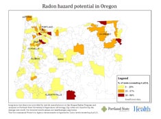
What did Tracking do?
The Oregon Tracking Program and partners developed maps showing radon hazards for areas smaller than counties. Tracking staff used these maps to support public education to encourage in-home radon testing during January 2013, Radon Action Month. They published the radon maps on the health department’s Radon Program web pages and on Oregon Tracking’s Facebook page. They sent news releases to media outlets announcing the maps and providing information about radon testing.
Improved public health
Television news coverage and two front-page articles in The Oregonian newspaper about the maps helped raise public awareness of radon hazards and encourage radon testing. Following the media coverage, monthly average visits to the Radon Program’s web pages tripled. Data from the American Lung Association (ALA) of Oregon showed that they sold nearly 300 test kits during the first day the front page Oregonian article ran. Within three days, ALA sold more radon test kits online than they did in the entire year of 2012. Increases in radon testing likely will lead to more people taking steps to decrease the amount of radon they come in contact with.
South Carolina – Protecting Adults from Lead Exposure

What is the problem?
Even though lead poisoning often is considered to be a children’s health issue, hobbies or jobs can put adults at risk. Exposure to high levels of lead can damage the brain, nerves, and kidneys. Symptoms of lead exposure may not be noticed until blood lead levels are very high. The Occupational Safety and Health Administration requires blood lead testing for some workers to ensure that they are not overexposed to lead.
What did Tracking do?
The South Carolina Tracking Program built and maintains a database of blood lead testing results for the state. They initiate follow up for cases of elevated lead results in children. And, they partner with the SC Occupational Safety and Health Administration (SC OSHA) to monitor adult blood lead levels. Tracking staff create quarterly reports on elevated adult blood lead levels. SC OSHA uses the information in these reports to decide where to conduct targeted inspections of worksites where employees’ blood lead levels were above regulation limits.
Improved public health
The SC Tracking Program identified 89 cases of elevated blood lead levels in occupational settings in 2012. As a result, SC OSHA inspected four workplaces and issued citations containing 15 violations. Some worksites were required to pay fines and all were required to reduce lead exposures. Workers in these locations now have safer work environments where their risk for lead exposure has been decreased or eliminated.